ArcBurn
A new project phase integrating fire behavior modeling with archaeological material science to evaluate fire risk to cultural resources and support fire management decision processes
Contact: Rachel Loehman and Grant Snitker
Identifying needs and developing new decision support tools for cultural resources
Cultural resources are artifacts, sites, structures, landscapes, and objects of importance connected to the physical presence, practices, and/or spirituality of past and present peoples1,2. These are managed under multiple local, state, tribal, and federal laws and regulations (e.g., NEPA, NHPA) and can be highly vulnerable to impacts from wildfires. Increasing demand for knowledge about how fire impacts archaeological materials has led to several laboratory and field-based studies on the effects of wildfire (i.e. heat, duration of exposure, etc.) on specific artifacts and materials (ceramics, stone tools, rock art, historic wooden structures, etc.)2. However, connecting these adverse effects to fuel conditions, fire behavior, and protection measures has not been evaluated. Protecting cultural resources during wildfire incidents is often left to post hoc decision-making as resource advisors are not equipped with the necessary analytical tools to accomplish in-depth pre-planning. We propose the development of an analytical tool kit tailored to assist cultural resource managers in 1) evaluating fuel conditions that may contribute to fire behavior that is damaging to cultural resources; 2) determining the most appropriate mitigation/treatment strategies to reduce risk of adverse effects in both pre-fire planning and during a wildfire incident; and 3) assessing pre- and post-fire archaeological site conditions using standardized and comparable strategies that consider immediate and long-term fire effects and burn severity.
This project uses a novel, new approach to assessing risk to cultural resources by incorporating recent developments fire behavior modeling to estimate archaeological site-level fuel conditions, fire energy release, and fuel consumption that can lead to adverse effects on archaeological materials. The majority of this work will rely on ongoing fire behavior modeling (QUIC-fire)3 and 3D fuels characterization4–6 conducted at the USDA Forest Service Southern Research Station in Athens, GA. Using the arrangement of actual fuels within archaeological sites as inputs for QUIC-fire will allow us to run multiple parameter configurations to simulate multiple fire behaviors and combustion conditions, ranging from low-intensity prescribed fire to extreme, crown fire conditions. From these simulations, we will be able to identify fuel conditions and fire behavior that could result in damage to archaeological material integrity, interpretive value, and cultural significance.
The data needs and specificity of simulation models for individual archaeological make it unfeasible to generate simulations for all archaeological sites within large burn areas, let alone an entire USFS Ranger District or National Forest. Instead, we view this work as an opportunity to develop training sets of diverse archaeological materials and fuel types that can be synthesized into categorical models of fire risk for broad application. We propose disseminating model results and information about fuels by developing a photo series guide for archaeologists, which outlines the specific fuel loadings, fuel size classes, and other important fuel characteristics typical of an ecoregion that can impact cultural resources under a range of fire behaviors. We will work with cultural resource managers, fireline archaeologists, and other practitioners, to tailor this photo series for easy integration with the workflows of recording, revisits, and monitoring of archaeological sites. Coupling this information with pre- and post-fire condition reporting, we will be able to create a more cohesive and systematic workflow for evaluating risk to these sites.
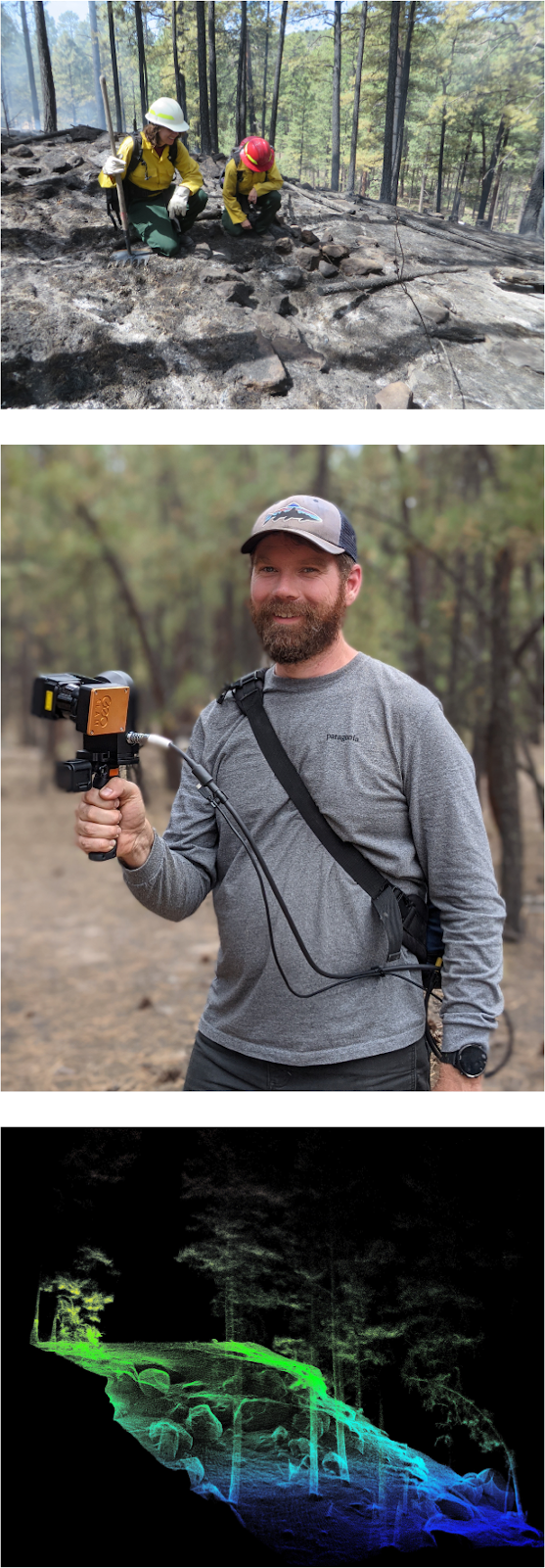
Current project status and future data needs
A feasibility study was conducted during September 2021 on the Jemez Ranger District of the Santa Fe National Forest in New Mexico. Three study plots, each measuring approximately 200 meters by 200 meters, were scanned using a handheld, terrestrial LiDAR unit to collect spatially explicit point clouds of fuels and terrain needed to create our initial simulations in QUIC-fire. The scanning portion of this project was successful, and all point clouds contain sufficient point density and spatial coverage to build voxelized, 3-D fuel inputs. Additionally, above ground archaeological features (e.g., Puebloan masonry structures) were visible in our scans, as well as previous treatments (e.g., hand-piled fuels). A standardized pre- and post-fire condition reporting workflow targeting long-term impacts to archaeological sites is currently under development and will be used to monitor archaeological sites during an upcoming prescribed fire (Holiday Mesa Rx Burn, planned for November 2022).
Future phases of this project will build on the feasibility study to include additional 3-D fuel characterizations to capture variable fuels, topography, and archaeological site types on ranger districts throughout the Santa Fe National Forest. From these study areas, model scenarios will be built in QUIC-fire to evaluate how ignitions, fuel conditions, and treatments affect fire behavior and archaeological site integrity. Experimental results will be used to generate risk profiles for archaeological materials and overlying fuels, as well as evaluate the effectiveness of on-site fuel treatments or other mitigations strategies. A pilot photo series guide for archaeologists and a standardized condition reporting workflow will be generated by synthesizing experimental results for the Santa Fe National Forest. If the development of this toolkit proves successful, we will draw on our contacts within the fire archaeology and wildfire resource advisor networks to adapt these products for other public lands throughout the US, including prescribed fire hubs in the southeast and wildfire-prone regions of the west.
References
- Friggens, M. M., Loehman, R. A., Constan, C. I. & Kneifel, R. R. Predicting wildfire impacts on the prehistoric archaeological record of the Jemez Mountains, New Mexico, USA. Fire Ecol. 17, 18 (2021).
- Ryan, K. C., Jones, T. A., Koerner, C. L. & Lee, K. M. Wildland fire in ecosystems: effects of fire on cultural resources and archaeology. vol. 3 224 http://treesearch.fs.fed.us/pubs/40417 (2012).
- Linn, R. R. et al. QUIC-fire: A fast-running simulation tool for prescribed fire planning. Environ. Model Softw. 125, 104616 (2020).
- Hawley, C. M., Loudermilk, E. L., Rowell, E. M. & Pokswinski, S. A novel approach to fuel biomass sampling for 3D fuel characterization. MethodsX 5, 1597–1604 (2018).
- Rowell, E., Loudermilk, E. L., Seielstad, C. & O’Brien, J. J. Using Simulated 3D Surface Fuelbeds and Terrestrial Laser Scan Data to Develop Inputs to Fire Behavior Models. Can. J. Remote. Sens. 42, 443–459 (2016).
- Rowell, E. et al. Coupling terrestrial laser scanning with 3D fuel biomass sampling for advancing wildland fuels characterization. For. Ecol. Manag. 462, 117945 (2020).